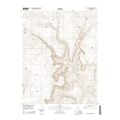
2014 Map of Bull Valley Gorge
USGS Topo · Published 2014About this map
Bull Valley Gorge and the White Cliffs dominate this portion of Kane County, where the desert floor is carved by intricate drainage systems. The Paria River cuts through the eastern half of the region, joined by smaller tributaries like Willis Creek and Rock Springs Cr. This 2014 survey documents a landscape of dramatic elevation changes, from the high Deer Range to the depths of Deer Creek Canyon. Human presence is represented primarily by primitive roads such as Deer Springs Rd and Road 530, which navigate around natural barriers like Little Bull Valley and Rock Springs Bench. The map illustrates the geological transition from the lower Indian Hollow to the expansive Little Dry Valley, providing a detailed look at the complex topography and seasonal waterways of the Utah canyonlands.
Find a feature on this map
26 named features on this map. Tap any name to fly to it.
Don’t see what you’re looking for? This feature index may not catch every label — zoom into the map to look around manually.
Map Details
Editions of this 2014 Bull Valley Gorge Map
This is the sole edition of this map. No revisions or reprints were ever made.
Other maps of this area

1886 · Kanab
USGS Topo · 1:250,000

1886 · Escalante
USGS Topo · 1:250,000

1953 · Cedar City
USGS Topo · 1:250,000

1955 · The Cockscob SW
USGS Topo · 1:24,000

1956 · Escalante
USGS Topo · 1:250,000

1958 · Cedar City
USGS Topo · 1:250,000

1960 · Escalante
USGS Topo · 1:250,000

1962 · Cedar City
USGS Topo · 1:250,000

1964 · Henrieville
USGS Topo · 1:24,000
1964 · Calico Peak
USGS Topo · 1:24,000