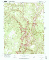
1966 Map of Bull Valley Gorge
USGS Topo · Published 1968About this map
Bull Valley Gorge and the White Cliffs dominate this mid-1960s landscape, revealing the intricate drainage patterns that define the northern reaches of Kane County. The terrain is characterized by a series of high benches and deep-cut canyons, most notably Averett Canyon and the winding course of the Paria River which carves through the eastern portion of the quadrangle. High plateaus such as Rock Springs Bench and the Deer Range stand between the many dry washes and creeks, including Sheep Creek and Willis Creek.
Find a feature on this map
22 named features on this map. Tap any name to fly to it.
Don’t see what you’re looking for? This feature index may not catch every label — zoom into the map to look around manually.
Map Details
Editions of this 1966 Bull Valley Gorge Map
2 editions found
Other maps of this area

1886 · Kanab
USGS Topo · 1:250,000

1886 · Escalante
USGS Topo · 1:250,000

1953 · Cedar City
USGS Topo · 1:250,000

1955 · The Cockscob SW
USGS Topo · 1:24,000

1956 · Escalante
USGS Topo · 1:250,000

1958 · Cedar City
USGS Topo · 1:250,000

1960 · Escalante
USGS Topo · 1:250,000

1962 · Cedar City
USGS Topo · 1:250,000

1964 · Henrieville
USGS Topo · 1:24,000
1964 · Calico Peak
USGS Topo · 1:24,000