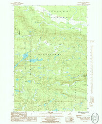
1985 Map of Bulldog Lake
USGS Topo · Published 1985About this map
The Cyrus H McCormick Experimental Forest anchors this high-elevation wilderness in the 1980s, marking a landscape defined by significant hydrological sources and conservation boundaries. Straddling the line between Baraga and Marquette counties, the terrain is characterized by a dense network of glacial lakes and headwaters, including the remote Bulldog Lake and White Deer Lake. To the north, the Yellow Dog Plains give way to the West Branch Yellow Dog River, while the southern reaches contain the Silver Lake Basin and the winding Dead River.
Find a feature on this map
27 named features on this map. Tap any name to fly to it.
Don’t see what you’re looking for? This feature index may not catch every label — zoom into the map to look around manually.
Map Details
Editions of this 1985 Bulldog Lake Map
This is the sole edition of this map. No revisions or reprints were ever made.
Other maps of this area

1954 · Huron Mountain
USGS Topo · 1:62,500

1954 · Skanee
USGS Topo · 1:62,500

1955 · Champion
USGS Topo · 1:24,000

1955 · Diorite
USGS Topo · 1:24,000

1955 · Champion
USGS Topo · 1:62,500

1956 · Michigamme
USGS Topo · 1:62,500

1956 · Michigamme
USGS Topo · 1:24,000

1958 · Marquette
USGS Topo · 1:250,000

1958 · Iron River
USGS Topo · 1:250,000

1960 · Iron River
USGS Topo · 1:250,000
Featured Places
- L'Anse Township, MI
- Michigamme Township, MI
- Champion Township, MI
- Marquette County, MI
- Baraga County, MI