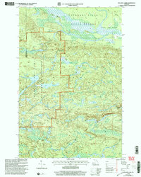
1999 Map of Bulldog Lake
USGS Topo · Published 2004About this map
The McCormick Wilderness within the Ottawa National Forest defines this part of Marquette County, preserving a landscape of interconnected water bodies and dense woods at the close of the twentieth century. The map highlights a significant hydrological divide where the Dead River Headwaters begin their journey, contrasting with the Escanaba River and Yellow Dog River systems. Settlement is nearly absent, represented only by a lone Gravel Pit and a few specialized markers like the Panorama Lookout.
Find a feature on this map
31 named features on this map. Tap any name to fly to it.
Don’t see what you’re looking for? This feature index may not catch every label — zoom into the map to look around manually.
Map Details
Editions of this 1999 Bulldog Lake Map
This is the sole edition of this map. No revisions or reprints were ever made.
Other maps of this area

1954 · Huron Mountain
USGS Topo · 1:62,500

1954 · Skanee
USGS Topo · 1:62,500

1955 · Champion
USGS Topo · 1:24,000

1955 · Diorite
USGS Topo · 1:24,000

1955 · Champion
USGS Topo · 1:62,500

1956 · Michigamme
USGS Topo · 1:62,500

1956 · Michigamme
USGS Topo · 1:24,000

1958 · Marquette
USGS Topo · 1:250,000

1958 · Iron River
USGS Topo · 1:250,000

1960 · Iron River
USGS Topo · 1:250,000
Featured Places
- L'Anse Township, MI
- Michigamme Township, MI
- Champion Township, MI
- Marquette County, MI
- Baraga County, MI