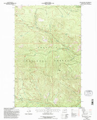
1992 Map of Bulldog Mtn
USGS Topo · Published 1996About this map
Colville National Forest dominates this landscape in northern Ferry County, defined by the steep elevation gains between the drainage basins of Boulder Creek and its many tributaries. The area is marked by prominent high points including Bulldog Mtn, Dry Mountain, and Hunter Mountain, which are separated by significant relief and timbered slopes. The drainage patterns are intricate, with North Fork Boulder Creek and South Fork Boulder Creek carving deep valleys through the terrain. Evidence of localized industry is sparse but present, noted by a Borrow Pit and several bench marks such as BM 51lm 3864 and BM 49lm 2977 that document the early surveying efforts across North Boulder Ridge and Taylor Ridge. Numerous named water sources like Tamarack Spring and Laddie Creek suggest a landscape where water management was vital for the forest's utility and maintenance during the late twentieth century.
Find a feature on this map
31 named features on this map. Tap any name to fly to it.
Don’t see what you’re looking for? This feature index may not catch every label — zoom into the map to look around manually.
Map Details
Editions of this 1992 Bulldog Mtn Map
This is the sole edition of this map. No revisions or reprints were ever made.
Other maps of this area

1936 · Marcus
USGS Topo · 1:96,000

1942 · Marcus
USGS Topo · 1:125,000

1948 · Sherman Peak
USGS Topo · 1:62,500

1948 · Kettle Falls
USGS Topo · 1:62,500

1948 · Orient
USGS Topo · 1:62,500

1948 · Togo Mountain
USGS Topo · 1:62,500

1951 · Togo Mountain
USGS Topo · 1:62,500

1951 · Sherman Peak
USGS Topo · 1:62,500

1951 · Orient
USGS Topo · 1:62,500

1951 · Kettle Falls
USGS Topo · 1:62,500