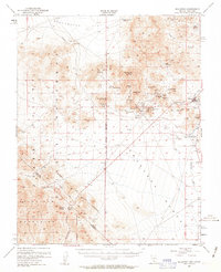
1954 Map of Bullfrog
USGS Topo · Published 1963About this map
Rhyolite and the surrounding mining districts in the Bullfrog Hills are captured during a mid-century period of transition, following the peak of the gold rush that defined this corner of the Amargosa Desert. The landscape is heavily marked by its industrial heritage, featuring the Original Bullfrog Mine and a web of others including the Denver Mine, Gibraltar Mine, and Mayflower Mine. This 1954 survey shows a Dismantled Railroad tracking south toward the state line, a remnant of the infrastructure that once connected these desert boomtowns to the outside world.
Find a feature on this map
51 named features on this map. Tap any name to fly to it.
Don’t see what you’re looking for? This feature index may not catch every label — zoom into the map to look around manually.
Map Details
Editions of this 1954 Bullfrog Map
3 editions found

Other maps of this area

1908 · Kawich
USGS Topo · 1:250,000

1908 · Lida
USGS Topo · 1:250,000

1908 · Furnace Creek
USGS Topo · 1:250,000

1908 · Ballarat
USGS Topo · 1:250,000

1910 · Furnace Creek
USGS Topo · 1:250,000

1913 · Lida
USGS Topo · 1:250,000

1913 · Ballarat
USGS Topo · 1:250,000

1942 · Tolicha Peak
USGS Topo · 1:125,000

1942 · Bullfrog
USGS Topo · 1:125,000

1948 · Death Valley
USGS Topo · 1:250,000