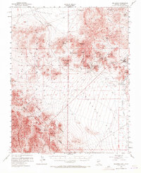
1954 Map of Bullfrog
USGS Topo · Published 1972About this map
The Bullfrog Hills and the northern reaches of Death Valley National Monument dominate this mid-century survey of the Nevada-California border. The landscape is defined by the legacy of early 20th-century gold mining, centered on the remains of Rhyolite and the nearby Bullfrog settlement. These mining camps are surrounded by numerous workings, including the Original Bullfrog Mine, Gibraltar Mine, and Ladd Mine. The town of Beatty serves as the regional hub in the Oasis Valley, connected to the defunct mining centers by the path of a dismantled railroad that once ran through the Amargosa Narrows.
Find a feature on this map
51 named features on this map. Tap any name to fly to it.
Don’t see what you’re looking for? This feature index may not catch every label — zoom into the map to look around manually.
Map Details
Editions of this 1954 Bullfrog Map
3 editions found

Other maps of this area

1908 · Kawich
USGS Topo · 1:250,000

1908 · Lida
USGS Topo · 1:250,000

1908 · Furnace Creek
USGS Topo · 1:250,000

1908 · Ballarat
USGS Topo · 1:250,000

1910 · Furnace Creek
USGS Topo · 1:250,000

1913 · Lida
USGS Topo · 1:250,000

1913 · Ballarat
USGS Topo · 1:250,000

1942 · Tolicha Peak
USGS Topo · 1:125,000

1942 · Bullfrog
USGS Topo · 1:125,000

1948 · Death Valley
USGS Topo · 1:250,000