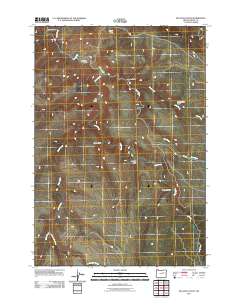
2011 Map of Bullock Gulch
USGS Topo · Published 2011About this map
Bullock Gulch and the surrounding drainages of Grant County define this high-desert landscape in Eastern Oregon. The terrain is deeply incised by watercourses such as Long Creek and Pass Creek, which create a complex network of canyons and gulches. Named features like Jackson Gulch, Stone Gulch, and Cottonwood Gulch provide specific reference points for researchers and genealogists interested in the land divisions of this region. The map reveals a sparse infrastructure, with only a few corridors like Piquet Rd traversing the topography. The arrangement of basins, such as Linder Basin in the north, suggests a landscape primarily shaped by natural drainage patterns rather than dense settlement, offering a clear view of the area's physical geography at the start of the 21st century.
Find a feature on this map
15 named features on this map. Tap any name to fly to it.
Don’t see what you’re looking for? This feature index may not catch every label — zoom into the map to look around manually.
Map Details
Editions of this 2011 Bullock Gulch Map
This is the sole edition of this map. No revisions or reprints were ever made.
Other maps of this area

1949 · Long Creek
USGS Topo · 1:62,500

1950 · Ritter
USGS Topo · 1:62,500

1951 · Long Creek
USGS Topo · 1:62,500

1951 · Courtrock
USGS Topo · 1:62,500

1951 · Monument
USGS Topo · 1:62,500

1952 · Ritter
USGS Topo · 1:62,500

1955 · Canyon City
USGS Topo · 1:250,000

1959 · Canyon City
USGS Topo · 1:250,000

1980 · Monument
USGS Topo · 1:100,000
1990 · Steet Mtn.
USGS Topo · 1:24,000