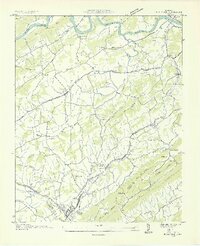
1935 Map of Bulls Gap
USGS Topo · Published 1935About this map
The Bulls Gap rail junction serves as a focal point for this 1935 survey, where the Southern railroad cuts through the gap between Bays Mountain and Piney Mountain. This area of East Tennessee is defined by a dense network of country schools and churches that anchored rural life in the mid-1930s, including Walkers Sch, Thorps Ch, and Morrissetts Chapel. Along the northern edge, the Holston River winds past Longs Island, with the Melendy Ferry providing a river crossing before the widespread bridging of the era.
Find a feature on this map
68 named features on this map. Tap any name to fly to it.
Don’t see what you’re looking for? This feature index may not catch every label — zoom into the map to look around manually.
Map Details
Editions of this 1935 Bulls Gap Map
2 editions found
Other maps of this area

1883 · Morristown
USGS Topo · 1:125,000

1892 · Greeneville
USGS Topo · 1:125,000

1893 · Morristown
USGS Topo · 1:125,000

1895 · Morristown
USGS Topo · 1:125,000

1896 · Greeneville
USGS Topo · 1:125,000

1904 · Greeneville
USGS Topo · 1:125,000

1935 · Surgoinsville
USGS Topo · 1:48,000

1935 · Rogersville
USGS Topo · 1:48,000

1935 · Lee Valley
USGS Topo · 1:24,000

1935 · McCloud
USGS Topo · 1:24,000