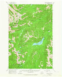
1962 Map of Bumping Lake
USGS Topo · Published 1964About this map
Bumping Lake serves as the central anchor for this 1962 topographic survey of the Washington Cascades, where the Snoqualmie National Forest meets the eastern boundary of Mt. Rainier Nat. Park. The map documents a rugged landscape defined by high alpine peaks like Fifes Peaks and Mount Aix, punctuated by numerous high-altitude basins and lakes. Human activity is largely centered around recreational access and early mineral extraction, with several unnamed Mines and the Copper City (Site) located in the southern reaches. The settlement of Goose Prairie near the lake’s eastern shore stands as a rare outpost of habitation in a territory otherwise dominated by an extensive network of trails, such as the Cascade Crest Trail and American Ridge Trail. This survey captures the region's wilderness character just before the mid-century expansion of outdoor recreation infrastructure, noting established sites like Lodgepole Campground and Bumping Crossing Campground.
Find a feature on this map
120 named features on this map. Tap any name to fly to it.
Don’t see what you’re looking for? This feature index may not catch every label — zoom into the map to look around manually.
Map Details
Editions of this 1962 Bumping Lake Map


Other maps of this area

1901 · Snoqualmie Pass
USGS Topo · 1:125,000

1902 · Mount Aix
USGS Topo · 1:125,000

1903 · Snoqualmie
USGS Topo · 1:125,000

1904 · Mt Aix
USGS Topo · 1:125,000

1913 · Cedar Lake
USGS Topo · 1:125,000

1924 · Mt Rainier
USGS Topo · 1:96,000

1928 · Mt Rainier
USGS Topo · 1:125,000

1950 · Yakima
USGS Topo · 1:250,000
1956 · Greenwater
USGS Topo · 1:62,500

1957 · Wenatchee
USGS Topo · 1:250,000