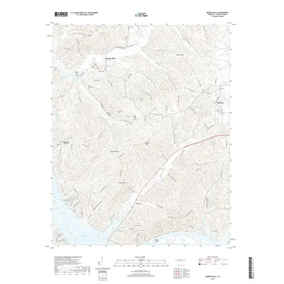
2019 Map of Bumpus Mills
USGS Topo · Published 2019About this map
Lake Barkley dominates the southern reaches of this Stewart County landscape, where the waters of Pool Two meet the northern tip of Dover Island. The terrain north of the lake is a complex network of ridges and deep hollows, including Yarborough Hollow and Sugar Camp Hollow, which have historically dictated the placement of small settlements and family burial grounds. The community of Bumpus Mills sits at the confluence of several streams, including Saline Cr and Wall Cr, while Big Rock serves as another focal point for the region's rural road network.
Find a feature on this map
128 named features on this map. Tap any name to fly to it.
Don’t see what you’re looking for? This feature index may not catch every label — zoom into the map to look around manually.
Map Details
Editions of this 2019 Bumpus Mills Map
This is the sole edition of this map. No revisions or reprints were ever made.
Other maps of this area

1931 · Erin
USGS Topo · 1:62,500

1936 · Tharpe
USGS Topo · 1:24,000

1936 · Standing Rock
USGS Topo · 1:24,000

1936 · Dover
USGS Topo · 1:24,000

1950 · Standing Rock
USGS Topo · 1:24,000

1950 · Dover
USGS Topo · 1:24,000

1951 · Model
USGS Topo · 1:24,000

1951 · Roaring Spring
USGS Topo · 1:24,000

1951 · Johnson Hollow
USGS Topo · 1:24,000
1951 · Tharpe
USGS Topo · 1:24,000