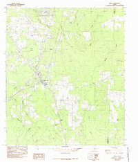
1984 Map of Buna
USGS Topo · Published 1985About this map
Buna serves as the central hub of this East Texas survey, where the local road network and railroad lines converge in Jasper County. To the north, the settlement of Bessmay sits along the rail line, while the southern landscape is characterized by the elevation at Bunker Hill. The terrain is defined by a dense network of slow-moving water and wetlands, including the expansive Phillips Thicket and the tidal-adjacent Hollis Marsh near the Newton County line. Numerous family-named tributaries like Strawther Branch, Goode Branch, and Nance Branch drain the piney woods into larger systems such as Cypress Creek and Gum Slough. This mapping reflects a rural landscape shaped by the timber industry and small-town settlement patterns, preserving the locations of homes and local infrastructure as they existed in the mid-1970s and early 1980s.
Find a feature on this map
18 named features on this map. Tap any name to fly to it.
Don’t see what you’re looking for? This feature index may not catch every label — zoom into the map to look around manually.
Map Details
Editions of this 1984 Buna Map
This is the sole edition of this map. No revisions or reprints were ever made.
Other maps of this area

1952 · Lake Charles
USGS Topo · 1:250,000

1954 · Lake Charles
USGS Topo · 1:250,000

1954 · Beaumont
USGS Topo · 1:250,000

1955 · Silsbee
USGS Topo · 1:62,500

1955 · Bessmay
USGS Topo · 1:62,500

1957 · Beaumont
USGS Topo · 1:250,000

1958 · Spurger
USGS Topo · 1:62,500

1958 · Kirbyville
USGS Topo · 1:62,500

1984 · Beaumont
USGS Topo · 1:250,000

1984 · Potato Patch Lake
USGS Topo · 1:24,000