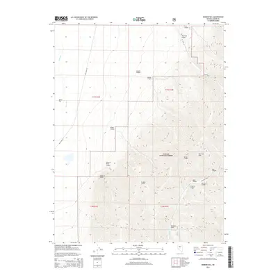
2014 Map of Bunker Hill
USGS Topo · Published 2014About this map
Toiyabe National Forest dominates this high-altitude landscape of central Nevada, where the steep eastern slopes of the Toiyabe Range drop into deep drainages. The topography is defined by prominent peaks like Big Creek Peak, which anchors a network of branching canyons including Big Creek Canyon and Kingston Canyon. These corridors have historically provided access into the interior of the range, as evidenced by Big Creek Rd and Kingston Canyon Rd. To the west, the land transitions at Point of Rocks toward the more level Dutch Flat, where the Reese River meanders north. The map reveals a drainage pattern of seasonal creeks and named gulches like Mahogany Gulch, illustrating the importance of water management in this arid environment where Kingston Cr and Big Cr carve through the limestone and granite of the basin-and-range country.
Find a feature on this map
27 named features on this map. Tap any name to fly to it.
Don’t see what you’re looking for? This feature index may not catch every label — zoom into the map to look around manually.
Map Details
Editions of this 2014 Bunker Hill Map
This is the sole edition of this map. No revisions or reprints were ever made.
Other maps of this area

1955 · Millett
USGS Topo · 1:250,000

1956 · North Shoshone Peak
USGS Topo · 1:62,500

1956 · Millett Ranch
USGS Topo · 1:62,500

1956 · Austin
USGS Topo · 1:62,500

1959 · Millett
USGS Topo · 1:250,000

1969 · Gandolfo Canyon
USGS Topo · 1:24,000

1969 · Dutch Flat
USGS Topo · 1:24,000

1985 · Smith Creek Valley
USGS Topo · 1:100,000
1988 · Austin
USGS Topo · 1:24,000
1988 · Bunker Hill
USGS Topo · 1:24,000