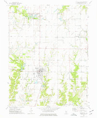
1974 Map of Bunker Hill
USGS Topo · Published 1977About this map
Bunker Hill serves as the central hub of this Macoupin County landscape, surrounded by an extensive network of small family cemeteries and agricultural lands during the mid-1970s. The town's infrastructure includes the Bunker Hill Reservoir and nearby Sewage Disposal Ponds, reflecting its status as a local population center. To the northeast, the smaller settlements of Dorchester and Baylestown sit along an Old Grade Railroad, which underscores the historical importance of rail transport in moving goods across the Illinois prairie.
Find a feature on this map
39 named features on this map. Tap any name to fly to it.
Don’t see what you’re looking for? This feature index may not catch every label — zoom into the map to look around manually.
Map Details
Editions of this 1974 Bunker Hill Map
This is the sole edition of this map. No revisions or reprints were ever made.
Other maps of this area

1912 · Gillespie
USGS Topo · 1:62,500

1915 · Gillespie
USGS Topo · 1:62,500

1925 · Brighton
USGS Topo · 1:62,500

1927 · Alton
USGS Topo · 1:62,500

1927 · Edwardsville
USGS Topo · 1:62,500

1928 · Brighton
USGS Topo · 1:62,500

1932 · Edwardsville
USGS Topo · 1:62,500

1934 · Alton
USGS Topo · 1:62,500

1948 · Quincy
USGS Topo · 1:250,000

1949 · Saint Louis
USGS Topo · 1:250,000