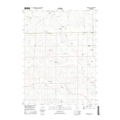
2015 Map of Bunker Hill
USGS Topo · Published 2015About this map
North Fabius River and its numerous tributaries, including Batten Branch and Brush Creek, carve a rolling landscape across the border of Iowa and Missouri. This modern record of the area shows a pattern of rural settlement defined by small crossroads like Lunsford and Bunker Hill, alongside larger communities such as Savannah. The map is particularly useful for genealogical research, documenting numerous family and community burial grounds including Bridwell Cemetery, Howell Cemetery, New Zion Cemetery, and Walker Chapel Cemetery. Infrastructure is primarily agricultural, evidenced by the Newcomb Hereford Ranch Airport and a network of secondary roads such as Hale School Road and Sanchez Road. In the southeast, Lancaster City Lake and the Downing Reservoir stand as key water management features in this river-valley terrain.
Find a feature on this map
60 named features on this map. Tap any name to fly to it.
Don’t see what you’re looking for? This feature index may not catch every label — zoom into the map to look around manually.
Map Details
Editions of this 2015 Bunker Hill Map
This is the sole edition of this map. No revisions or reprints were ever made.
Other maps of this area

1903 · Edina
USGS Topo · 1:125,000

1911 · Queen City
USGS Topo · 1:62,500

1913 · Queen City
USGS Topo · 1:62,500

1954 · Centerville
USGS Topo · 1:250,000

1957 · Centerville
USGS Topo · 1:250,000

1958 · Centerville
USGS Topo · 1:250,000

1965 · Downing NW
USGS Topo · 1:24,000

1966 · Downing
USGS Topo · 1:24,000
1974 · Queen City NE
USGS Topo · 1:24,000
1979 · Queen City
USGS Topo · 1:24,000