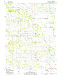
1980 Map of Bunker Hill
USGS Topo · Published 1980About this map
The North Fabius River and its various forks dominate this 1980 survey, illustrating a landscape defined by drainage patterns across the Missouri-Iowa border. Small rural settlements like Savannah and Lunsford are documented alongside the community of Bunker Hill, which sits near the eastern edge of the quadrangle. The map reveals a high density of small-scale country landmarks, particularly churches and family-named cemeteries such as Darby Ch, Pleasant Grove Ch, and Walker Chapel Cem, which offer significant value for genealogical research in this border region.
Find a feature on this map
26 named features on this map. Tap any name to fly to it.
Don’t see what you’re looking for? This feature index may not catch every label — zoom into the map to look around manually.
Map Details
Editions of this 1980 Bunker Hill Map
This is the sole edition of this map. No revisions or reprints were ever made.
Other maps of this area

1903 · Edina
USGS Topo · 1:125,000

1911 · Queen City
USGS Topo · 1:62,500

1913 · Queen City
USGS Topo · 1:62,500

1954 · Centerville
USGS Topo · 1:250,000

1957 · Centerville
USGS Topo · 1:250,000

1958 · Centerville
USGS Topo · 1:250,000

1965 · Downing NW
USGS Topo · 1:24,000

1966 · Downing
USGS Topo · 1:24,000
1974 · Queen City NE
USGS Topo · 1:24,000
1979 · Queen City
USGS Topo · 1:24,000