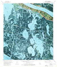
1973 Map of Buras
USGS Topo · Published 1976About this map
The Mississippi River defines the northern corridor of this 1973 orthophotomap, where the settlement of Buras sits protected by a prominent levee system. This specialized survey blends traditional topographic data with aerial photography, revealing the intricate, water-logged geography of Plaquemines Parish as it meets the Gulf of Mexico. The landscape south of the river is a complex network of marshes and open water, including Adams Bay, Scofield Bay, and Cyprien and Gas Field Bay. Infrastructure for the local energy and maritime economy is evident through features like the Buras Boat Harbor, scattered Oil Wells, and the Radio Tower. Large conservation tracts like the Bohemia State Wildlife Management Area occupy the eastern bank, illustrating the region's character as a critical habitat where land and sea constantly shift.
Find a feature on this map
37 named features on this map. Tap any name to fly to it.
Don’t see what you’re looking for? This feature index may not catch every label — zoom into the map to look around manually.
Map Details
Editions of this 1973 Buras Map
This is the sole edition of this map. No revisions or reprints were ever made.
Other maps of this area

1892 · Quarantine
USGS Topo · 1:62,500

1893 · Forts
USGS Topo · 1:62,500

1893 · West Delta
USGS Topo · 1:62,500

1935 · Port Sulphur
USGS Topo · 1:31,680

1935 · Bastian Bay
USGS Topo · 1:31,680

1935 · Tropical Bend
USGS Topo · 1:31,680

1941 · Empire
USGS Topo · 1:62,500

1944 · Empire
USGS Topo · 1:62,500

1946 · Pass Tante Phine
USGS Topo · 1:31,680

1947 · Buras
USGS Topo · 1:31,680