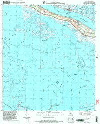
1998 Map of Buras
USGS Topo · Published 2003About this map
Buras and Ostrica anchor this Plaquemines Parish landscape, situated on the narrow ribbon of land between the Mississippi River and the complex wetlands of the Mississippi Delta. Protected by a continuous Levee, the inhabited corridor includes local landmarks like the High Sch Cem and the Buras Boat Harbor. The map reveals the critical intersection of natural hydrology and industrial extraction, dominated by the West Bastian Bay Oil and Gas Field and the Cyprien and Bay Gas Field. Beyond the levees, a network of waterways including Tortillon Bayou, Gazeau Canal, and English Bay illustrates the region's precarious geography. Traces of coastal features like Pelican Island and Shell Island at the southern edge show the proximity to the open Gulf, where a Heliport and numerous pipelines serve the offshore energy industry.
Find a feature on this map
61 named features on this map. Tap any name to fly to it.
Don’t see what you’re looking for? This feature index may not catch every label — zoom into the map to look around manually.
Map Details
Editions of this 1998 Buras Map
This is the sole edition of this map. No revisions or reprints were ever made.
Other maps of this area

1892 · Quarantine
USGS Topo · 1:62,500

1893 · Forts
USGS Topo · 1:62,500

1893 · West Delta
USGS Topo · 1:62,500

1935 · Port Sulphur
USGS Topo · 1:31,680

1935 · Bastian Bay
USGS Topo · 1:31,680

1935 · Tropical Bend
USGS Topo · 1:31,680

1941 · Empire
USGS Topo · 1:62,500

1944 · Empire
USGS Topo · 1:62,500

1946 · Pass Tante Phine
USGS Topo · 1:31,680

1947 · Buras
USGS Topo · 1:31,680