
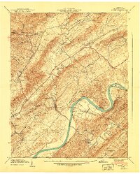
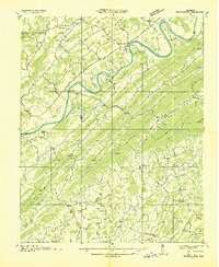
1940 Map of Burem
USGS Topo · Published 1940About this map
Hennard Mill and the surrounding valley farms define this 1940 portrait of Hawkins County, where the Holston River carves through a landscape of parallel ridges and valleys. The river serves as the central artery, featuring the prominent Bussells Bend and islands like Miller Island and Burem Island. This survey captures a network of rural communities, each anchored by its own religious and educational landmarks, from Alumwell Academy in the north to the McKinney Sch further south.
Find a feature on this map
65 named features on this map. Tap any name to fly to it.
Don’t see what you’re looking for? This feature index may not catch every label — zoom into the map to look around manually.
Map Details
Editions of this 1940 Burem Map
2 editions found
Other maps of this area

1883 · Morristown
USGS Topo · 1:125,000

1887 · Jonesville
USGS Topo · 1:125,000

1891 · Jonesville
USGS Topo · 1:125,000

1892 · Greeneville
USGS Topo · 1:125,000

1893 · Morristown
USGS Topo · 1:125,000

1894 · Estillville
USGS Topo · 1:125,000

1895 · Morristown
USGS Topo · 1:125,000

1896 · Greeneville
USGS Topo · 1:125,000

1904 · Greeneville
USGS Topo · 1:125,000
1935 · Surgoinsville
USGS Topo · 1:48,000