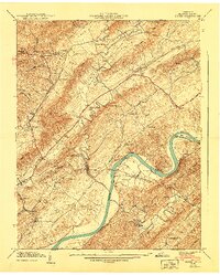
1940 Map of Burem
USGS Topo · Published 1940About this map
Holston River carves a serpentine path through this 1939 Tennessee Valley Authority field examination, defining the landscape of Hawkins County. The river's dramatic Bussels Bend anchors the central terrain, bordered by the Southern railroad line. This era captures a rural economy sustained by landmarks like Hennard Mill and the Pumping Station, alongside established social centers including Alumwell Academy and Magnolia Sch. The map reveals a high density of country churches and family burial grounds, such as Cedar Grove Ch and Ward Cem, which provide essential clues for genealogical research. One particularly distinctive natural feature, the Ebbing and Flowing Spring, highlights the unique hydrology of the area, while settlements like Yellow Store and Gillenwater show the distribution of population across the valley and ridge system just before mid-century modernization.
Find a feature on this map
76 named features on this map. Tap any name to fly to it.
Don’t see what you’re looking for? This feature index may not catch every label — zoom into the map to look around manually.
Map Details
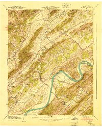
Editions of this 1940 Burem Map
2 editions found
Other maps of this area

1883 · Morristown
USGS Topo · 1:125,000

1887 · Jonesville
USGS Topo · 1:125,000

1891 · Jonesville
USGS Topo · 1:125,000

1892 · Greeneville
USGS Topo · 1:125,000

1893 · Morristown
USGS Topo · 1:125,000

1894 · Estillville
USGS Topo · 1:125,000

1895 · Morristown
USGS Topo · 1:125,000

1896 · Greeneville
USGS Topo · 1:125,000

1904 · Greeneville
USGS Topo · 1:125,000

1935 · Surgoinsville
USGS Topo · 1:48,000