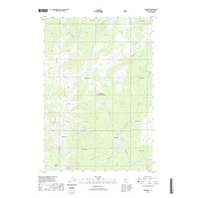
2020 Map of Burgdorf
USGS Topo · Published 2020About this map
Burgdorf, situated at the convergence of several high-mountain drainages, serves as a focal point for this Idaho County landscape. Known for its Hot Springs, the settlement is surrounded by the deep drainages of Burgdorf Cr and Nethker Creek. The terrain is dominated by significant elevations such as Bear Pete Mtn and Crystal Mtn, with Bear Pete Ridge forming a massive north-south spine across the western half of the map. High-altitude water bodies like Marshall Lake and Bear Pete Lake drain into a complex network of creeks, including Jeanette Creek and the Secesh River. This region within the Payette National Forest shows a transportation network reliant on established routes like Warren Wagon Rd and Burgdorf Rd, which connect the isolated meadows and thermal features of the high backcountry.
Find a feature on this map
53 named features on this map. Tap any name to fly to it.
Don’t see what you’re looking for? This feature index may not catch every label — zoom into the map to look around manually.
Map Details
Editions of this 2020 Burgdorf Map
This is the sole edition of this map. No revisions or reprints were ever made.
Other maps of this area

1938 · Riggins
USGS Topo · 1:96,000

1945 · Riggins
USGS Topo · 1:125,000

1955 · Grangeville
USGS Topo · 1:250,000

1956 · Burgdorf
USGS Topo · 1:62,500

1956 · Elk City
USGS Topo · 1:250,000

1959 · Grangeville
USGS Topo · 1:250,000

1960 · Elk City
USGS Topo · 1:250,000

1963 · Black Tip
USGS Topo · 1:24,000

1963 · Hershey Point
USGS Topo · 1:24,000
1964 · Kelly Mountain
USGS Topo · 1:24,000