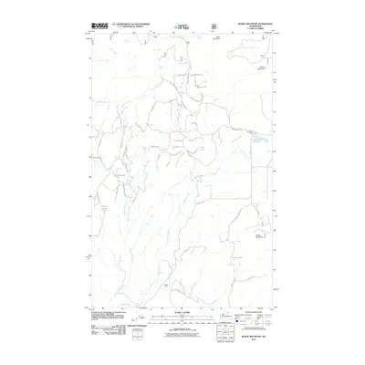
2011 Map of Burge Mountain
USGS Topo · Published 2011About this map
Burge Mountain and Wilcox Mountain anchor this high-country landscape in northern Washington, where a complex network of seasonal creeks and named springs supports local resource extraction and ranching. The presence of Fancher Quarry and infrastructure like Fanchers Dam suggests a landscape defined by utility and land management. Water is a critical focus on this map, evidenced by the numerous mapped sources including Twin Springs, Tamarack Spring, and Camp Spring, which feed into drainage systems like Antoine Creek and Whisky Cache Creek. This survey reflects the modern rural character of Okanogan County, where residential access via roads like Swanson Mill Rd and Bonanza Dr meets the working terrain of the mountains and smaller bodies of water like Oberg Lake and Green Lake.
Find a feature on this map
60 named features on this map. Tap any name to fly to it.
Don’t see what you’re looking for? This feature index may not catch every label — zoom into the map to look around manually.
Map Details
Editions of this 2011 Burge Mountain Map
This is the sole edition of this map. No revisions or reprints were ever made.
Other maps of this area

1902 · Osoyoos
USGS Topo · 1:125,000

1904 · Osoyoos
USGS Topo · 1:125,000

1954 · Okanogan
USGS Topo · 1:250,000

1957 · Mt. Bonaparte
USGS Topo · 1:62,500

1957 · Tonasket
USGS Topo · 1:62,500

1957 · Oroville
USGS Topo · 1:62,500

1957 · Aeneas Valley
USGS Topo · 1:62,500

1958 · Okanogan
USGS Topo · 1:250,000

1975 · Oroville NW
USGS Topo · 1:24,000
1981 · Tonasket
USGS Topo · 1:24,000