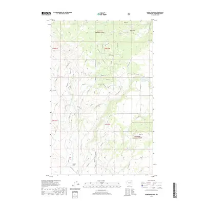
2020 Map of Burge Mountain
USGS Topo · Published 2020About this map
Antoine Valley sits at the southern reach of this Okanogan County landscape, where the terrain transitions from open valley floors to the high ridges of the Okanogan National Forest. This modern survey reveals a network of mountain springs and remote drainages, including Tamarack Spring and Wildhorse Spring, which feed into local systems like Whisky Cache Cr and Antoine Cr. The northern section is dominated by significant peaks such as Haley Mtn and Wilcox Mtn, crossed by the high-elevation route of the Pacific NW National Scenic Trail. Water management is evident through features like the Fanchers Dam Reservoir and Green Lake, while a complex web of modern access roads—including Swanson Mill Rd and Havillah Rd—connects the dispersed valley properties to the surrounding timberlands.
Find a feature on this map
76 named features on this map. Tap any name to fly to it.
Don’t see what you’re looking for? This feature index may not catch every label — zoom into the map to look around manually.
Map Details
Editions of this 2020 Burge Mountain Map
This is the sole edition of this map. No revisions or reprints were ever made.
Other maps of this area

1902 · Osoyoos
USGS Topo · 1:125,000

1904 · Osoyoos
USGS Topo · 1:125,000

1954 · Okanogan
USGS Topo · 1:250,000

1957 · Mt. Bonaparte
USGS Topo · 1:62,500

1957 · Tonasket
USGS Topo · 1:62,500

1957 · Oroville
USGS Topo · 1:62,500

1957 · Aeneas Valley
USGS Topo · 1:62,500

1958 · Okanogan
USGS Topo · 1:250,000

1975 · Oroville NW
USGS Topo · 1:24,000
1981 · Tonasket
USGS Topo · 1:24,000