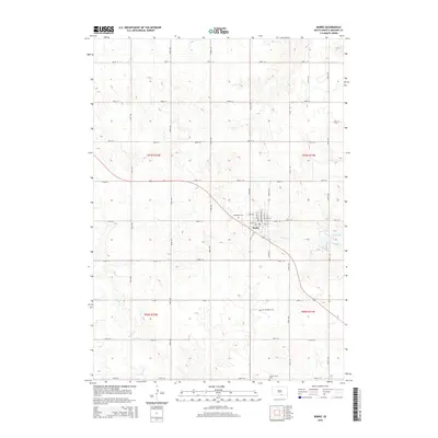
2015 Map of Burke
USGS Topo · Published 2015About this map
Burke serves as the central hub of this Gregory County landscape, where the grid of the town site meets the diagonal path of the highway and the winding course of Coon Cr. The map illustrates a settled agricultural region defined by a regular Section-line road system, including routes like 344th Ave and 290th St. To the northwest of the town center lies Graceland Cem, while Sacred Heart Cem and the County Home Cem are situated to the south, providing specific locations for genealogical research. Water features are concentrated in the eastern and southern portions of the quadrangle, notably at Lake Burke and along the drainage of Ponca Cr. The detailed street plan of the town itself identifies local thoroughfares such as Washington St and Main St, showing the footprint of the community in the mid-2010s.
Find a feature on this map
39 named features on this map. Tap any name to fly to it.
Don’t see what you’re looking for? This feature index may not catch every label — zoom into the map to look around manually.
Map Details
Editions of this 2015 Burke Map
This is the sole edition of this map. No revisions or reprints were ever made.
Other maps of this area

1955 · Mitchell
USGS Topo · 1:250,000

1959 · Mitchell
USGS Topo · 1:250,000

1964 · Gregory SE
USGS Topo · 1:24,000

1964 · Herrick NW
USGS Topo · 1:24,000

1964 · Gregory
USGS Topo · 1:24,000
1964 · Herrick
USGS Topo · 1:24,000
1964 · Carlock
USGS Topo · 1:24,000
1964 · Burke
USGS Topo · 1:24,000

1971 · Dixon SW
USGS Topo · 1:24,000

1971 · Lucas
USGS Topo · 1:24,000