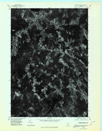
1975 Map of Burnham SE
USGS Topo · Published 1980About this map
The agrarian landscape of central Waldo County is revealed in this 1975 orthophoto, where small-scale farming and timber lots create a distinct patchwork across the terrain. Rural crossroads and village centers anchor the region, with Unity situated in the north near the shores of Unity Pond and Freedom positioned toward the south. The imagery captures the transition of mid-1970s Maine, showing the persistent footprint of long-established hamlets like Thorndike and Farwells Corner.
Find a feature on this map
7 named features on this map. Tap any name to fly to it.
Don’t see what you’re looking for? This feature index may not catch every label — zoom into the map to look around manually.
Map Details
Editions of this 1975 Burnham SE Map
This is the sole edition of this map. No revisions or reprints were ever made.
Other maps of this area

1915 · Belfast
USGS Topo · 1:62,500

1916 · Liberty
USGS Topo · 1:62,500

1917 · Belfast
USGS Topo · 1:62,500

1926 · Burnham
USGS Topo · 1:62,500

1932 · Brooks
USGS Topo · 1:62,500

1941 · Belfast
USGS Topo · 1:62,500

1942 · Liberty
USGS Topo · 1:62,500

1948 · Bangor
USGS Topo · 1:250,000

1950 · Belfast
USGS Topo · 1:50,000

1950 · Liberty
USGS Topo · 1:50,000