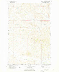
1972 Map of Burning Mine Butte
USGS Topo · Published 1976About this map
Burning Mine Butte stands as a prominent landmark in this landscape of the Missouri River plateau in McKenzie County, North Dakota. The drainage patterns of the early 1970s are intricately detailed, showing how Spring Creek and its various branches, including Burning Mine Creek, carve through the terrain. Evidence of early rural infrastructure remains visible through the presence of the Stevenson Sch and the uniquely named Poker Jim Cem in the southeastern portion of the quadrangle. These features, along with Mile Butte and Hayward Dam, reflect a ranching and farming environment where water management and local community centers were vital. The map also traces various seasonal watercourses such as Forked Creek and Covered Bridge Creek, providing a clear record of the area's hydrology before modern intensive land-use changes.
Find a feature on this map
18 named features on this map. Tap any name to fly to it.
Don’t see what you’re looking for? This feature index may not catch every label — zoom into the map to look around manually.
Map Details
Editions of this 1972 Burning Mine Butte Map
This is the sole edition of this map. No revisions or reprints were ever made.
Other maps of this area

1953 · Watford City
USGS Topo · 1:250,000

1957 · Watford City
USGS Topo · 1:250,000

1967 · Watford City
USGS Topo · 1:250,000

1972 · Bear Butte
USGS Topo · 1:24,000

1972 · Moline School
USGS Topo · 1:24,000

1972 · Sheep Creek
USGS Topo · 1:24,000

1972 · Sather Lake
USGS Topo · 1:24,000
1974 · Ice Box Canyon
USGS Topo · 1:24,000
1974 · Cinnamon Creek
USGS Topo · 1:24,000
1974 · Flat Rock Butte
USGS Topo · 1:24,000