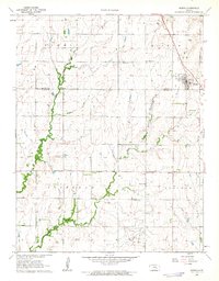
1962 Map of Burns
USGS Topo · Published 1963About this map
Burns stands as the primary settlement on this Kansas prairie landscape, situated near the intersection of the Marion Co Butler Co line. The town's grid is clearly defined, featuring a local townhall and proximity to an Old Railroad Grade that speaks to the changing transportation corridors of the mid-20th century. The surrounding countryside is divided into the townships of Summit, Milton, Clifford, and Lincoln, reflecting a traditional rural organization shaped by the Whitewater River and its tributaries like May Branch.
Find a feature on this map
20 named features on this map. Tap any name to fly to it.
Don’t see what you’re looking for? This feature index may not catch every label — zoom into the map to look around manually.
Map Details
Editions of this 1962 Burns Map
This is the sole edition of this map. No revisions or reprints were ever made.
Other maps of this area

1888 · Eldorado
USGS Topo · 1:125,000

1889 · Newton
USGS Topo · 1:125,000

1889 · Wichita
USGS Topo · 1:125,000

1894 · Wichita
USGS Topo · 1:125,000

1894 · Newton
USGS Topo · 1:125,000

1898 · Cottonwood Falls
USGS Topo · 1:125,000

1955 · Wichita
USGS Topo · 1:250,000

1955 · Hutchinson
USGS Topo · 1:250,000

1957 · Florence
USGS Topo · 1:24,000

1957 · Wonsevu
USGS Topo · 1:24,000