
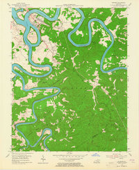
1954 Map of Burnside
USGS Topo · Published 1955About this map
Burnside serves as the focal point for this mid-century survey, situated at the dramatic confluence where the Lake Cumberland River and the South Fork Cumberland River meet. The landscape is defined by the sharp, serpentine meanders of the water, creating isolated peninsulas like Bunker Hill and deep bends such as Antioch Bend and Woodson Bend. The Southern railroad line cuts a north-south path through the center of the map, connecting smaller settlements like Tateville and Sloans Valley. Deep within the Cumberland National Forest, the topography is heavily dissected by hollows and ridges, including Sweet Lick Ridge and Dead Ox Hollow. For the local historian, the map preserves the exact placement of rural institutions such as Piney Grove Sch and Grave Hill Ch, alongside numerous family-named cemeteries that speak to the long-standing community ties of southern Pulaski County.
Find a feature on this map
74 named features on this map. Tap any name to fly to it.
Don’t see what you’re looking for? This feature index may not catch every label — zoom into the map to look around manually.
Map Details
Editions of this 1954 Burnside Map
2 editions found
Other maps of this area

1890 · Williamsburg
USGS Topo · 1:125,000

1893 · London
USGS Topo · 1:125,000

1894 · Williamsburg
USGS Topo · 1:125,000

1897 · London
USGS Topo · 1:125,000

1932 · Burnside
USGS Topo · 1:62,500

1935 · Somerset
USGS Topo · 1:62,500

1952 · Hail
USGS Topo · 1:24,000

1952 · Wiborg
USGS Topo · 1:24,000

1952 · Dykes
USGS Topo · 1:24,000

1953 · Frazer
USGS Topo · 1:24,000