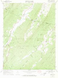
1969 Map of Burnsville
USGS Topo · Published 1970About this map
Jackson River winds through a landscape of parallel ridges in this late 1960s survey of the Virginia highlands. The settlement of Burnsville and the village of Bolar anchor the valley communities, which are defined by their proximity to the water and the sheltering peaks of Jack Mountain and Warm Springs Mountain. Religious and social life is evident through landmarks such as Stony Run Ch, Valley Bethel Ch, and Starr Chapel, alongside family burial grounds like Cleek Cem.
Find a feature on this map
52 named features on this map. Tap any name to fly to it.
Don’t see what you’re looking for? This feature index may not catch every label — zoom into the map to look around manually.
Map Details
Editions of this 1969 Burnsville Map
3 editions found
Other maps of this area

1901 · Monterey
USGS Topo · 1:125,000

1922 · Cass
USGS Topo · 1:48,000

1923 · Warm Springs
USGS Topo · 1:48,000

1924 · Cass
USGS Topo · 1:62,500

1926 · Warm Springs
USGS Topo · 1:62,500

1930 · Warm Springs Run
USGS Topo · 1:24,000

1933 · Warm Springs Run
USGS Topo · 1:31,680

1941 · Monterey
USGS Topo · 1:62,500

1944 · Monterey
USGS Topo · 1:62,500

1946 · Warm Springs
USGS Topo · 1:62,500