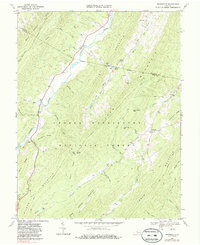
1969 Map of Burnsville
USGS Topo · Published 1986About this map
Jackson River defines the western valley of this mountain landscape, marking a core corridor for travel and settlement between Little Mountain and Jack Mountain. The George Washington National Forest encompasses the majority of the terrain, where early roads and jeep trails navigate the steep rises of White Rock Mtn and Wilson Mountain. Small community clusters like Burnsville and Bolar appear along the valley floors, supported by local gathering points such as Valley Bethel Ch and Stony Run Ch. Genealogists may find value in the scattered burial sites, including Cleek Cem and Big Valley Cem, which are tucked away near the many namesake runs that feed the primary river system. High points like Duncan Knob and the Lookout Tower on Tower Hill Mountain provided essential vantage points for monitoring this heavily forested borderland between Bath and Highland counties.
Find a feature on this map
53 named features on this map. Tap any name to fly to it.
Don’t see what you’re looking for? This feature index may not catch every label — zoom into the map to look around manually.
Map Details
Editions of this 1969 Burnsville Map
3 editions found
Other maps of this area

1901 · Monterey
USGS Topo · 1:125,000

1922 · Cass
USGS Topo · 1:48,000

1923 · Warm Springs
USGS Topo · 1:48,000

1924 · Cass
USGS Topo · 1:62,500

1926 · Warm Springs
USGS Topo · 1:62,500

1930 · Warm Springs Run
USGS Topo · 1:24,000

1933 · Warm Springs Run
USGS Topo · 1:31,680

1941 · Monterey
USGS Topo · 1:62,500

1944 · Monterey
USGS Topo · 1:62,500

1946 · Warm Springs
USGS Topo · 1:62,500