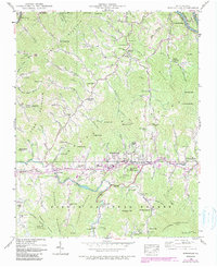
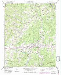
1939 Map of Burnsville
USGS Topo · Published 1990About this map
Burnsville serves as the focal point of this late 1930s survey, situated along the Cane River and surrounded by the peaks of Cane Mountain and the Bailey Hills. The map reveals a landscape defined by mountain agriculture and early development, including the State Prison Camp along the river and the Mt Mitchell Boys Camp just south of town. These features, along with the numerous mountain gaps and coves like Johnson Cove, illustrate the area's difficult topography and the way transportation followed the river valleys.
Find a feature on this map
105 named features on this map. Tap any name to fly to it.
Don’t see what you’re looking for? This feature index may not catch every label — zoom into the map to look around manually.
Map Details
Editions of this 1939 Burnsville Map
5 editions found
Other maps of this area

1891 · Roan Mountain
USGS Topo · 1:125,000

1894 · Roan Mountain
USGS Topo · 1:125,000

1900 · Mount Mitchell
USGS Topo · 1:125,000

1902 · Mount Mitchell
USGS Topo · 1:125,000

1904 · Roan Mountain
USGS Topo · 1:125,000

1934 · Micaville
USGS Topo · 1:24,000

1934 · Parts Of Celo And Black Brothers
USGS Topo · 1:24,000

1934 · Bakersville
USGS Topo · 1:24,000

1935 · Black Brothers
USGS Topo · 1:24,000

1935 · Chestoa
USGS Topo · 1:24,000