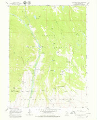
1965 Map of Burnt Mill Spring
USGS Topo · Published 1979About this map
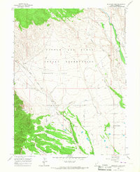
The Yellowstone River and its tributary, Swift Creek, dominate this high-altitude landscape in the mid-1960s. This territory sits at the intersection of the Ashley National Forest and the Uintah and Ouray Indian Reservation, where the transition from river bottom to high mountain basins like Harmston Basin is marked by steep canyons and prominent geological features such as the Yellowstone Ledges.
Find a feature on this map
87 named features on this map. Tap any name to fly to it.
Don’t see what you’re looking for? This feature index may not catch every label — zoom into the map to look around manually.
Map Details
Editions of this 1965 Burnt Mill Spring Map
2 editions found

Other maps of this area

1885 · Uinta
USGS Topo · 1:250,000

1905 · Gilbert Peak
USGS Topo · 1:125,000

1906 · Gilbert Peak
USGS Topo · 1:125,000
1939 · Duchesne
USGS Topo · 1:125,000

1954 · Salt Lake City
USGS Topo · 1:250,000

1958 · Salt Lake City
USGS Topo · 1:250,000

1960 · Salt Lake City
USGS Topo · 1:250,000
1965 · Mount Emmons
USGS Topo · 1:24,000
1965 · Heller Lake
USGS Topo · 1:24,000
1965 · Mountain Home
USGS Topo · 1:24,000