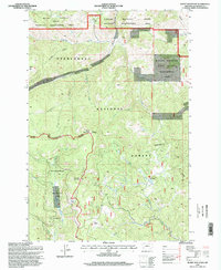
1996 Map of Burnt Mountain
USGS Topo · Published 1998About this map
High-altitude administrative and wilderness management sites define this mid-1990s survey of the Continental Divide region. The High Rye Work Center serves as a lone operational anchor in a landscape dominated by the DEERLODGE NATIONAL FOREST and BEAVERHEAD NATIONAL FOREST. The map traces the sharp topography of the divide as it weaves through the summit of Burnt Mountain and along the Fleecer Ridge, illustrating the intricate boundaries between state-managed wildlife areas and federal forest lands. This edition reflects the specialized land use of the era, where remote outposts supported forest service operations and wildlife management across the rugged transitions of the Fleecer Mountain State Wildlife Management Area. Researchers will find a precise record of late 20th-century forest boundaries and the network of improved and unimproved roads that provided access to these remote Montana highlands.
Find a feature on this map
1 named feature on this map. Tap any name to fly to it.
Don’t see what you’re looking for? This feature index may not catch every label — zoom into the map to look around manually.
Map Details
Editions of this 1996 Burnt Mountain Map
This is the sole edition of this map. No revisions or reprints were ever made.
Other maps of this area

1889 · Helena
USGS Topo · 1:250,000

1893 · Helena
USGS Topo · 1:250,000

1893 · Dillon
USGS Topo · 1:250,000

1899 · Helena
USGS Topo · 1:250,000

1903 · Helena
USGS Topo · 1:250,000

1947 · Butte
USGS Topo · 1:250,000

1955 · Dillon
USGS Topo · 1:250,000

1957 · Dillon
USGS Topo · 1:250,000

1958 · Butte
USGS Topo · 1:250,000

1958 · Dillon
USGS Topo · 1:250,000