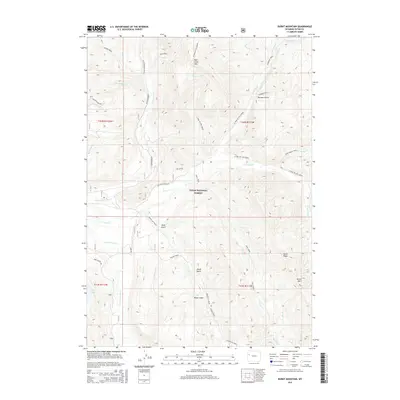
2015 Map of Burnt Mountain
USGS Topo · Published 2015About this map
Teton National Forest defines this high-elevation landscape in Teton County, where the topography is shaped by a dense network of drainages feeding into the Gros Ventre River. The map reveals a remote wilderness characterized by steep ridges and named gulches, such as Alkali Gulch and Wolf Gulch, which drop toward the winding path of Bacon Creek. Movement through this mountainous terrain is primarily dictated by pack trails and forest roads, including the Purdy Basin Trail and the Bacon Cr (Pack) trail. At the southern end of the sheet, Soda Lake provides a rare stationary water feature amidst the complex hydrology of Sohare Cr, Dog Cr, and Fish Cr. This 2015 study is particularly valuable for its recording of specific landform names like Deer Creek Mtn and Burnt Ridge, reflecting the geographical nomenclature used by forest managers and backcountry travelers.
Find a feature on this map
46 named features on this map. Tap any name to fly to it.
Don’t see what you’re looking for? This feature index may not catch every label — zoom into the map to look around manually.
Map Details
Editions of this 2015 Burnt Mountain Map
This is the sole edition of this map. No revisions or reprints were ever made.
Other maps of this area

1902 · Mt Leidy
USGS Topo · 1:125,000

1907 · Gros Ventre
USGS Topo · 1:125,000

1910 · Gros Ventre
USGS Topo · 1:125,000

1955 · Driggs
USGS Topo · 1:250,000

1958 · Driggs
USGS Topo · 1:250,000

1962 · Driggs
USGS Topo · 1:250,000

1965 · Green Mountain
USGS Topo · 1:24,000
1965 · Lava Mountain
USGS Topo · 1:24,000
1965 · Sheridan Pass
USGS Topo · 1:24,000
1965 · Upper Slide Lake
USGS Topo · 1:24,000