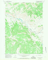
1965 Map of Upper Slide Lake
USGS Topo · Published 1968About this map
The Gros Ventre River carves a path through this 1965 survey of the Teton National Forest, where steep ridgelines like the Gray Hills drop into the expansive Yellowjacket Flat. The landscape is defined by the geologically significant Upper Slide Lake, formed by historic landslides, and the remote Goosewing Guard Sta that managed this wilderness. Traces of early industrial interest appear at the Coal Mine and scattered Prospects in the northern draws. The map illustrates a high-altitude drainage network including Goosewing Creek and Lightning Creek, connected only by an intricate system of Pack Trails and Jeep Trails rather than established roads. This connectivity pattern reflects the mid-century wilderness management era before modern infrastructure reached deep into the backcountry, preserving the isolation of landmarks like Gunsight Pass and Echo Park.
Find a feature on this map
32 named features on this map. Tap any name to fly to it.
Don’t see what you’re looking for? This feature index may not catch every label — zoom into the map to look around manually.
Map Details
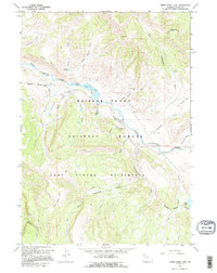
Editions of this 1965 Upper Slide Lake Map
2 editions found
Other maps of this area

1902 · Mt Leidy
USGS Topo · 1:125,000

1907 · Gros Ventre
USGS Topo · 1:125,000

1910 · Gros Ventre
USGS Topo · 1:125,000

1955 · Driggs
USGS Topo · 1:250,000

1958 · Driggs
USGS Topo · 1:250,000

1962 · Driggs
USGS Topo · 1:250,000

1965 · Green Mountain
USGS Topo · 1:24,000

1965 · Mount Leidy
USGS Topo · 1:24,000

1965 · Tripod Peak
USGS Topo · 1:24,000
1965 · Burnt Mountain
USGS Topo · 1:24,000