
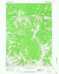
1965 Map of Mount Leidy
USGS Topo · Published 1968About this map
Mount Leidy stands as the prominent peak of this high-elevation landscape within Teton National Forest, where a complex network of glacial and alpine drainage systems defines the terrain. The northern reaches are characterized by the Toppings Lakes and the headwaters of the North Fork Ditch Creek, while the southern boundary follows the path of the Gros Ventre River near the Lavender Hills. This mid-1960s survey reveals a backcountry relies on a system of Pack Trails and Jeep Trails rather than established roads, illustrating the area's isolation and its primary use for forest management or recreation. The naming of numerous tributaries, such as Slate Creek, Negrohead Fork, and Carmichael Fork, suggests a detailed local topography known primarily to forest rangers and pack outfitters during this era.
Find a feature on this map
23 named features on this map. Tap any name to fly to it.
Don’t see what you’re looking for? This feature index may not catch every label — zoom into the map to look around manually.
Map Details
Editions of this 1965 Mount Leidy Map
2 editions found
Other maps of this area

1899 · Grand Teton
USGS Topo · 1:125,000

1901 · Grand Teton
USGS Topo · 1:125,000

1902 · Mt Leidy
USGS Topo · 1:125,000

1955 · Driggs
USGS Topo · 1:250,000

1958 · Driggs
USGS Topo · 1:250,000

1962 · Driggs
USGS Topo · 1:250,000

1965 · Davis Hill
USGS Topo · 1:24,000

1965 · Green Mountain
USGS Topo · 1:24,000

1965 · Rosies Ridge
USGS Topo · 1:24,000
1965 · Upper Slide Lake
USGS Topo · 1:24,000