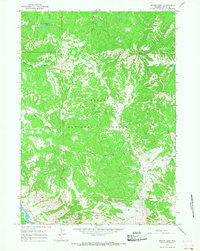
1965 Map of Mount Leidy
USGS Topo · Published 1968About this map
Mount Leidy stands as a prominent landmark within the Teton National Forest, overlooking a complex network of alpine drainages and high-country trails in the mid-1960s. The landscape is defined by the headwaters of several critical watercourses, including the Gros Ventre River and various forks of North Fork Ditch Creek and Middle Fork Ditch Creek. This era of the forest shows a reliance on seasonal access, with numerous pack trails and jeep trails providing the only passage through the steep terrain between Lavender Hills and the northern summits.
Find a feature on this map
25 named features on this map. Tap any name to fly to it.
Don’t see what you’re looking for? This feature index may not catch every label — zoom into the map to look around manually.
Map Details
Editions of this 1965 Mount Leidy Map
2 editions found
Other maps of this area

1899 · Grand Teton
USGS Topo · 1:125,000

1901 · Grand Teton
USGS Topo · 1:125,000

1902 · Mt Leidy
USGS Topo · 1:125,000

1955 · Driggs
USGS Topo · 1:250,000

1958 · Driggs
USGS Topo · 1:250,000

1962 · Driggs
USGS Topo · 1:250,000

1965 · Davis Hill
USGS Topo · 1:24,000

1965 · Green Mountain
USGS Topo · 1:24,000

1965 · Rosies Ridge
USGS Topo · 1:24,000

1965 · Mount Leidy
USGS Topo · 1:24,000