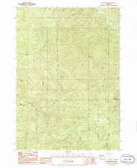
1986 Map of Burnt Mtn
USGS Topo · Published 1986About this map
The Calapooya Divide defines the high-altitude boundary between Lane and Douglas Counties, separating the headwaters of several major creek systems in this mid-1980s survey. The landscape is dominated by multiple prominent peaks, including Burnt Mtn, Fawn Peak, and Green Mtn, while the southern slopes descend toward the North Fork Calapooya Creek. The presence of numerous Quarry labels across these ridges indicates a period of active resource extraction, likely supporting the network of logging roads that lace through the timbered terrain. Notable topographic landmarks such as Lower Elk Meadows and Upper Elk Meadows sit just north of the divide, while the steep drainage of Box Canyon and the sharp turn at Cougar Bend illustrate the challenging geography of the Western Cascades. These features, along with named points like Kellys Bluff and Shirley Gap, provide specific reference points for tracing historical land use in this timber-rich region.
Find a feature on this map
33 named features on this map. Tap any name to fly to it.
Don’t see what you’re looking for? This feature index may not catch every label — zoom into the map to look around manually.
Map Details
Editions of this 1986 Burnt Mtn Map
This is the sole edition of this map. No revisions or reprints were ever made.
Other maps of this area

1897 · Roseburg
USGS Topo · 1:125,000

1900 · Roseburg
USGS Topo · 1:125,000

1935 · Lowell
USGS Topo · 1:96,000

1942 · Lowell
USGS Topo · 1:125,000

1954 · Anlauf
USGS Topo · 1:62,500

1954 · Glide
USGS Topo · 1:62,500

1955 · Mace Mtn
USGS Topo · 1:62,500

1955 · Culp Creek
USGS Topo · 1:62,500

1958 · Roseburg
USGS Topo · 1:250,000

1959 · Roseburg
USGS Topo · 1:250,000