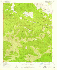
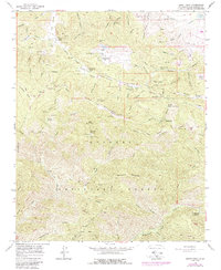
1958 Map of Burnt Peak
USGS Topo · Published 1959About this map
The San Andreas Rift Zone creates a distinctive tectonic depression across this portion of the Angeles National Forest, where high ridges and deep canyons define the landscape. This 1950s survey shows a sparsely populated region of Los Angeles County characterized by ranching and resource extraction, with locations like Kings Canyon Ranch and Sawmill Mtn Ranch scattered along the lower slopes. High-altitude landmarks such as Burnt Peak and Sawmill Mountain overlook a network of firebreaks and forest roads that connect remote outposts like the Pine Canyon Ranger Sta.
Find a feature on this map
73 named features on this map. Tap any name to fly to it.
Don’t see what you’re looking for? This feature index may not catch every label — zoom into the map to look around manually.
Map Details
Editions of this 1958 Burnt Peak Map
5 editions found
Other maps of this area

1903 · Tejon
USGS Topo · 1:125,000

1915 · Elizabeth Lake
USGS Topo · 1:125,000

1917 · Elizabeth Lake
USGS Topo · 1:125,000

1931 · Warm Spring
USGS Topo · 1:24,000

1931 · Redrock Mtn
USGS Topo · 1:24,000

1932 · Hughes Lake
USGS Topo · 1:24,000

1932 · Fairmont
USGS Topo · 1:24,000

1932 · Neenach
USGS Topo · 1:24,000

1933 · Manzana
USGS Topo · 1:24,000
1936 · Warm Spring
USGS Topo · 1:24,000