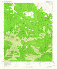
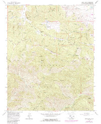
1958 Map of Burnt Peak
USGS Topo · Published 1965About this map
San Andreas Rift Zone geology dominates this 1958 survey, cutting a distinct path across the northern reaches of the Los Angeles National Forest. The landscape is a network of firebreaks and high-elevation mountain peaks, including Burnt Peak and Sawmill Mountain. Pockets of human activity are scattered throughout the rugged terrain, from the Tweedy Lake Club and Sawmill Mtn Ranch to secluded sites like Hidden Lake Ranch. Historic mining efforts are evidenced by the Big Chief Mine near Baldwin Grade and the Maxwell Mine to the south.
Find a feature on this map
83 named features on this map. Tap any name to fly to it.
Don’t see what you’re looking for? This feature index may not catch every label — zoom into the map to look around manually.
Map Details
Editions of this 1958 Burnt Peak Map
5 editions found
Other maps of this area

1903 · Tejon
USGS Topo · 1:125,000

1915 · Elizabeth Lake
USGS Topo · 1:125,000

1917 · Elizabeth Lake
USGS Topo · 1:125,000

1931 · Warm Spring
USGS Topo · 1:24,000

1931 · Redrock Mtn
USGS Topo · 1:24,000

1932 · Hughes Lake
USGS Topo · 1:24,000

1932 · Fairmont
USGS Topo · 1:24,000

1932 · Neenach
USGS Topo · 1:24,000

1933 · Manzana
USGS Topo · 1:24,000
1936 · Warm Spring
USGS Topo · 1:24,000