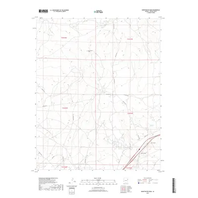
2018 Map of Burntwater Wash
USGS Topo · Published 2018About this map
Burntwater Wash defines this high-desert landscape in Apache County, where the dry channel cuts through the northern sections of the quadrangle. The terrain is characterized by a network of seasonal watercourses and primitive access routes, including Burntwater Rd and Pine Springs Rd. In the southeastern corner, the drainage systems converge as Querino Wash and the Puerco River traverse the territory near the notable geological formation of Box Canyon. The presence of Box Canyon Springs suggests a vital natural water source in this arid environment. This 2018 survey by the U.S. Geological Survey details a sparsely populated area primarily organized by the Public Land Survey System, with township and range lines like t22n r28e and t23n r29e providing the primary structure for navigation and land management.
Find a feature on this map
24 named features on this map. Tap any name to fly to it.
Don’t see what you’re looking for? This feature index may not catch every label — zoom into the map to look around manually.
Map Details
Editions of this 2018 Burntwater Wash Map
This is the sole edition of this map. No revisions or reprints were ever made.
Other maps of this area

1886 · Fort Defiance
USGS Topo · 1:250,000

1892 · Fort Defiance
USGS Topo · 1:250,000

1954 · Gallup
USGS Topo · 1:250,000

1958 · Gallup
USGS Topo · 1:250,000

1959 · Gallup
USGS Topo · 1:250,000

1962 · Gallup
USGS Topo · 1:250,000

1967 · Gallup
USGS Topo · 1:250,000

1971 · Wide Ruins
USGS Topo · 1:24,000

1971 · Burntwater Wash
USGS Topo · 1:24,000
1971 · Uranium Spring
USGS Topo · 1:24,000