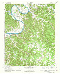
1968 Map of Burristown
USGS Topo · Published 1970About this map
Butlers Landing and the winding course of the Cumberland River define this Jackson County landscape during a period of significant hydrological change. The 1968 field check captures the area just as the Cordell Hull Reservoir began to transform the river valley, with blue hatching indicating the specific bottomlands slated for submersion, including portions of Weaver Bottom and Tinsley Bottom. The map provides a detailed look at rural life along the rugged Long Ridge and Tick Ridge.
Find a feature on this map
64 named features on this map. Tap any name to fly to it.
Don’t see what you’re looking for? This feature index may not catch every label — zoom into the map to look around manually.
Map Details
Editions of this 1968 Burristown Map
3 editions found
Other maps of this area

1897 · Standingstone
USGS Topo · 1:125,000

1898 · Standingstone
USGS Topo · 1:125,000

1924 · Lillydale
USGS Topo · 1:62,500

1925 · Gainesboro
USGS Topo · 1:62,500

1926 · Lillydale
USGS Topo · 1:62,500

1929 · Lillydale
USGS Topo · 1:62,500

1929 · Gainesboro
USGS Topo · 1:62,500

1929 · Tompkinsville
USGS Topo · 1:62,500

1951 · Windle
USGS Topo · 1:24,000
1955 · Hilham
USGS Topo · 1:24,000