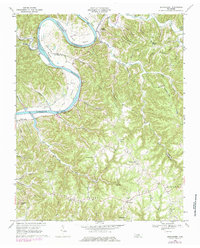
1968 Map of Burristown
USGS Topo · Published 1984About this map
The Cumberland River carves a deep path through the Jackson and Clay County borderlands, where the winding waterway passes Seven Sisters Bluff and circles the prominent Turkey Creek Island. By the late 1960s, the landscape reflects the significant impact of the Cordell Hull Reservoir project, which transformed the traditional river bottoms like Tinsley Bottom and Weaver Bottom. Local life is anchored in the uplands at Baptist Ridge and Tick Ridge, where small communities like Burristown and Butlers Landing serve as centers for the surrounding rural hollows. This survey records the social geography of the era through scattered landmarks such as Pleasant Hill Ch, Fairview Sch, and several family cemeteries, including the McDonald Cem. The network of local routes like Bell Dudney Road and Smoky Branch Road connect these ridge-top settlements to the changing river valley.
Find a feature on this map
73 named features on this map. Tap any name to fly to it.
Don’t see what you’re looking for? This feature index may not catch every label — zoom into the map to look around manually.
Map Details
Editions of this 1968 Burristown Map
3 editions found
Other maps of this area

1897 · Standingstone
USGS Topo · 1:125,000

1898 · Standingstone
USGS Topo · 1:125,000

1924 · Lillydale
USGS Topo · 1:62,500

1925 · Gainesboro
USGS Topo · 1:62,500

1926 · Lillydale
USGS Topo · 1:62,500

1929 · Lillydale
USGS Topo · 1:62,500

1929 · Gainesboro
USGS Topo · 1:62,500

1929 · Tompkinsville
USGS Topo · 1:62,500

1951 · Windle
USGS Topo · 1:24,000
1955 · Hilham
USGS Topo · 1:24,000