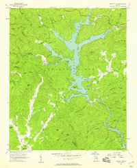
1957 Map of Burton Lake
USGS Topo · Published 1958About this map
Lake Burton dominates this 1957 terrain, a reservoir formed by the damming of the Tallulah River within the heart of the Chattahoochee National Forest. The map documents a landscape defined by water and mountain ridges, where family history is preserved in small burial grounds like Stoneycipher Cem and Burton Cem. Along the western slopes, the Soque River flows southward, passing the Providence Sch and the State Fish Hatchery. The intricate shoreline of the lake creates numerous coves, such as Timpson Cove and Mary Cove, which serve as landmarks for the scattered settlements like Lapardes. The presence of a Lookout Tower on Glassy Mtn and various benchmarks suggests the active management and surveying of this mountain region during the mid-century era.
Find a feature on this map
74 named features on this map. Tap any name to fly to it.
Don’t see what you’re looking for? This feature index may not catch every label — zoom into the map to look around manually.
Map Details
Editions of this 1957 Burton Lake Map
Other maps of this area

1886 · Dahlonega
USGS Topo · 1:125,000

1886 · Walhalla
USGS Topo · 1:125,000

1892 · Dahlonega
USGS Topo · 1:125,000

1892 · Walhalla
USGS Topo · 1:125,000

1896 · Walhalla
USGS Topo · 1:125,000

1896 · Dahlonega
USGS Topo · 1:125,000

1903 · Dahlonega
USGS Topo · 1:125,000

1935 · Osborn
USGS Topo · 1:24,000

1935 · Dillard
USGS Topo · 1:24,000

1935 · Hightower Bald
USGS Topo · 1:24,000