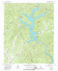
1957 Map of Lake Burton
USGS Topo · Published 1957About this map
Lake Burton and Seed Lake dominate this North Georgia landscape, where the waters of the Tallulah River are managed by spillways at defined elevations. The map reveals a mid-century recreational and agricultural environment, notably featuring Moccasin Creek State Park and the nearby State Fish Hatchery. The rugged terrain of the Chattahoochee National Forest is punctuated by significant local landmarks like the Lookout Tower on Glassy Mtn and the Providence Sch near the Soquee River. Genealogists will find numerous family and community landmarks, including the Burton Cem, Mt Zion Cem, and Staneyoaken Cem. The presence of Burton No 5 and the Scenic Highway along the eastern shoreline of the lake illustrates the area's development as a destination for travel and hydroelectric utility in the late 1950s.
Find a feature on this map
71 named features on this map. Tap any name to fly to it.
Don’t see what you’re looking for? This feature index may not catch every label — zoom into the map to look around manually.
Map Details
Editions of this 1957 Lake Burton Map
Other maps of this area

1886 · Dahlonega
USGS Topo · 1:125,000

1886 · Walhalla
USGS Topo · 1:125,000

1892 · Dahlonega
USGS Topo · 1:125,000

1892 · Walhalla
USGS Topo · 1:125,000

1896 · Walhalla
USGS Topo · 1:125,000

1896 · Dahlonega
USGS Topo · 1:125,000

1903 · Dahlonega
USGS Topo · 1:125,000

1935 · Osborn
USGS Topo · 1:24,000

1935 · Dillard
USGS Topo · 1:24,000

1935 · Hightower Bald
USGS Topo · 1:24,000