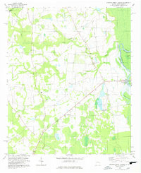
1978 Map of Burtons Ferry Landing
USGS Topo · Published 1978About this map
Savannah River bottomlands define the eastern border of this Georgia-South Carolina boundary region in the late 1970s. The landscape is marked by a network of drainage systems including Rocky Creek and McDaniel Creek, which feed into oxbow lakes like Mount Lake and Hershman Lake. The settlement pattern is largely rural and ecclesiastical, evidenced by numerous small congregations such as St Andrews Chapel, Bethel Brick Ch, and Wesley Chapel scattered across the Screven County countryside. Near the river, Burtons Ferry Landing serves as a local landmark, while the inland area near Millhaven features a private Landing Strip, suggesting the continued importance of both traditional water-based and modern air transport in this agricultural and timber-focused corner of the South.
Find a feature on this map
21 named features on this map. Tap any name to fly to it.
Don’t see what you’re looking for? This feature index may not catch every label — zoom into the map to look around manually.
Map Details
Editions of this 1978 Burtons Ferry Landing Map
This is the sole edition of this map. No revisions or reprints were ever made.
Other maps of this area

1919 · Allendale
USGS Topo · 1:62,500

1920 · Ellenton
USGS Topo · 1:48,000

1920 · Hilltonia
USGS Topo · 1:62,500

1920 · Peeples
USGS Topo · 1:62,500

1921 · Ellenton
USGS Topo · 1:62,500

1943 · Allendale
USGS Topo · 1:62,500

1943 · Hilltonia
USGS Topo · 1:62,500

1943 · Peeples
USGS Topo · 1:62,500

1943 · Augusta East
USGS Topo · 1:125,000

1943 · Millen
USGS Topo · 1:125,000