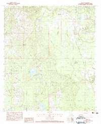
1983 Map of Bush
USGS Topo · Published 1983About this map
The Illinois Central Gulf railroad cuts a straight line through the piney woods of St. Tammany Parish, connecting the small settlements of Bush and Talisheek during the early 1980s. This landscape is defined by its intricate drainage networks, where Bogue Chitto sits at the northeastern corner and Talisheek Creek winds southward through the expansive Talisheek Swamp. The map reveals a deeply personal history of the area through numerous family-named landmarks and cemeteries, including the Lavinghouse Cem, Cowart Cem, and Grantham Cem. Civil infrastructure like the Waldheim Lookout Tower and the Fifth Ward Jr High Sch provide anchors for the rural community, while the presence of the Hillcrest Golf Course and various campgrounds suggests the transition of the land from purely timber and rail interests toward recreation and modern development.
Find a feature on this map
61 named features on this map. Tap any name to fly to it.
Don’t see what you’re looking for? This feature index may not catch every label — zoom into the map to look around manually.
Map Details
Editions of this 1983 Bush Map
This is the sole edition of this map. No revisions or reprints were ever made.
Other maps of this area

1935 · Slidell
USGS Topo · 1:62,500

1935 · Covington
USGS Topo · 1:62,500

1939 · Slidell
USGS Topo · 1:62,500

1939 · Zona
USGS Topo · 1:31,680

1939 · Covington
USGS Topo · 1:62,500

1942 · Waldheim
USGS Topo · 1:31,680

1942 · Talisheek
USGS Topo · 1:31,680

1942 · Rio
USGS Topo · 1:31,680

1942 · Walkiah Bluff
USGS Topo · 1:31,680

1942 · Pools Bluff
USGS Topo · 1:31,680