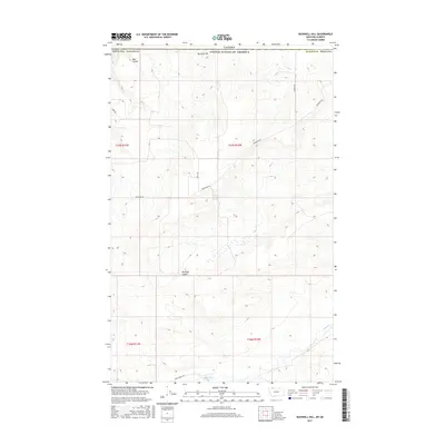
2017 Map of Bushnell Hill
USGS Topo · Published 2017About this map
The United States-Canada border forms the northern terminus of this map, where the high plains of Glacier County meet the international boundary. The landscape is defined by its drainage patterns, most notably the meandering course of the Milk River in the southern sections and the seasonal runoff channels of Bish Coulee and Kennedy Coulee. These coulees provide significant topographical relief against the surrounding plateaus, such as the prominent Bushnell Hill. A sparse network of gravel and dirt roads, including Buck Ranch Rd and Boundary Rd, connects isolated parcels of land in this remote borderland. The presence of the Hole-in-the-Wall Spring marks a rare perennial water source in an otherwise arid environment characterized by traditional cattle ranching and open range land.
Find a feature on this map
17 named features on this map. Tap any name to fly to it.
Don’t see what you’re looking for? This feature index may not catch every label — zoom into the map to look around manually.
Map Details
Editions of this 2017 Bushnell Hill Map
This is the sole edition of this map. No revisions or reprints were ever made.
Other maps of this area

1901 · Browning
USGS Topo · 1:125,000

1903 · Browning
USGS Topo · 1:125,000

1911 · Blackfoot
USGS Topo · 1:125,000

1960 · Cut Bank
USGS Topo · 1:250,000

1963 · Cut Bank
USGS Topo · 1:250,000

1964 · Cut Bank
USGS Topo · 1:250,000

1968 · Hoodoo Hill
USGS Topo · 1:24,000
1968 · Emigrant Gap
USGS Topo · 1:24,000
1968 · Del Bonita
USGS Topo · 1:24,000
1968 · Bushnell Hill
USGS Topo · 1:24,000