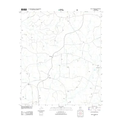
2012 Map of Busy Corner
USGS Topo · Published 2012About this map
The W Fork Amite River winds through this rural Amite County landscape, where small communities like Zion Hill and Busy Corner anchor a network of family farms and country roads. The area is exceptionally dense with family-named burial grounds, providing a significant resource for genealogists researching the residents of Ustane or Brookside. These sites, including Thomas Moore Cem, Old Parson Hill Cem, and the John Durham Cem, are scattered across the terrain, often located at the terminuses of winding lanes such as Pecan Orchard Rd. Transport and drainage are defined by numerous tributaries like Stokes Cr and Zion Hill Cr, which feed into the river basin. The settlement pattern remains sparse, characterized by individual homesteads and small clearings rather than concentrated urban development, reflecting the enduring agricultural character of this portion of southwest Mississippi.
Find a feature on this map
80 named features on this map. Tap any name to fly to it.
Don’t see what you’re looking for? This feature index may not catch every label — zoom into the map to look around manually.
Map Details
Editions of this 2012 Busy Corner Map
This is the sole edition of this map. No revisions or reprints were ever made.
Other maps of this area

1953 · Natchez
USGS Topo · 1:250,000

1956 · Natchez
USGS Topo · 1:250,000

1959 · Natchez
USGS Topo · 1:250,000

1961 · Liberty
USGS Topo · 1:62,500

1962 · Bude
USGS Topo · 1:62,500

1972 · Smithdale
USGS Topo · 1:24,000

1972 · Little Springs
USGS Topo · 1:24,000

1972 · Peoria
USGS Topo · 1:24,000

1984 · McComb
USGS Topo · 1:100,000
1988 · Homochitto
USGS Topo · 1:24,000