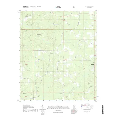
2021 Map of Busy Corner
USGS Topo · Published 2021About this map
Zion Hill and the surrounding Amite County landscape are defined by a network of small family cemeteries and rural congregations. The terrain is deeply carved by the W Fork Amite River and its many tributaries, including Zion Hill Cr and Knight Cr. The northern reaches of the sheet are dominated by the Homochitto National Forest, where the land transitions into managed timber and creek bottoms. Genealogical interest is particularly high here, as the map records numerous burial sites such as the Zion Hill Baptist Church Cem, Old Parson Hill Cem, and Nunnery Cem. These features, alongside small settlements like Ustane and Busy Corner, illustrate the dispersed settlement patterns of southwestern Mississippi. The infrastructure is primarily composed of local connectors like McGehee Rd SE and Rollinson Rd, which follow the contours of the drainage basins.
Find a feature on this map
88 named features on this map. Tap any name to fly to it.
Don’t see what you’re looking for? This feature index may not catch every label — zoom into the map to look around manually.
Map Details
Editions of this 2021 Busy Corner Map
This is the sole edition of this map. No revisions or reprints were ever made.
Other maps of this area

1953 · Natchez
USGS Topo · 1:250,000

1956 · Natchez
USGS Topo · 1:250,000

1959 · Natchez
USGS Topo · 1:250,000

1961 · Liberty
USGS Topo · 1:62,500

1962 · Bude
USGS Topo · 1:62,500

1972 · Smithdale
USGS Topo · 1:24,000

1972 · Little Springs
USGS Topo · 1:24,000

1972 · Peoria
USGS Topo · 1:24,000

1984 · McComb
USGS Topo · 1:100,000
1988 · Homochitto
USGS Topo · 1:24,000